Harmonica Arch Day Hike
 Yeti and I have done this hike a few times, and it’s been written-up here before. I searched for it online this morning and it appears that a dozen other people have written about it as well. Here is the most current version (for now)….
This one starts at the Goose Creek Trailhead on the eastern edge of Lost Creek Wilderness. Lost Creek is great for loop backpacking trips, but also has some features just inside the wilderness boundary that are worth a day trip. Goose Creek just below Harmonica Arch is one of those places. If you already know how to get to Goose Creek you can probably skip the next paragraph….
The Goose Creek Trailhead is off of Forest Road 211, which runs between Deckers and Tarryall Rd. (CO 77) just outside of Lake George. On the Deckers side this road is called Wigwam Creek Rd., and on the Tarryall side it is Matukat Rd. Whichever side you approach from, you’ll have to bounce down a forest road for 20 minutes to find the trailhead. The Matukat Rd. route is fairly straightforward, but if you come in on the Wigwam Creek side you’ll have to make a few turns to stay on 211. From the beginning of Wigwam Creek Rd on CO 126, snake uphill for 2 miles and take an unmarked right turn onto Goose Creek Rd. In another mile fork left toward Goose Creek (marked with a sign). After driving through the Hayman Burn for another 5.4 miles you must take a right turn just before entering private property. You’ll know you’re still on 211 because there is a “211” sign after the turn. After that, it’s another 4.8 miles to the turn for the Goose Creek Trailhead. It may sound like a maze of forest roads from this side, but actually there are only 3 intersections, so if you can remember “right, left, right” you can find your way through it.The Goose Creek Trailhead parking lot frequently fills up and overflows on the weekends. Show up really early or save this one for a weekday (Lost Creek Wilderness is usually pretty quiet during the week).
After driving down  211 for almost a half-hour you’re probably ready to get out of the car and start hiking. There is only one trail, Goose Creek, that sets out from here. The first half-mile goes through more of the Hayman Burn so you get to see the recovery up close. Follow the Goose Creek Trail down a big hill and cross a creek on a log bridge. The Hankins Pass trail begins after the bridge, but stay right to stick with the Goose Creek Trail. Within 1/4 mile it dips into the trees and joins Goose Creek, working its way upstream. Eventually, the trail takes a right and crosses Goose Creek on a metal bridge, but don’t cross that bridge. Instead, take the communal trail that stays on the left side of Goose Creek.
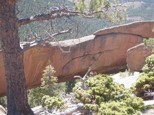
 This trail continues to follow the creek, staying next to the water and passing an occasional campsite. After a very small creek crossing you get a preview of the final destination (shown here). Carry on, staying next to the creek and passing a few more campsites. 1.7 miles (from the trailhead) you arrive at a very shady campsite that sits right on the water. At this point the trail turns left and begins up a steep gulch, departing from Goose Creek.
Over the next .8mi the trail will climb about 800′ through the gulch. It is steep, but there are only 2 or 3 very brief points that would be considered class III scrambling. As the trail bends from northwest to north through the gulch the trail becomes vague at times. In the past there have been several cairns set up on the rocks through here, but upon my last visit (early July, 2010) I found most of those cairns to be missing. If you suspect you have strayed off-trail, perch yourself on a rock or stump and scan around. The gulch is narrow and you’ll probably be able to locate the trail very quickly.
On final approach  to your destination the trail dumps out onto flat rock that is the base of the granite dome which contains the arch. Work your way up to the top of the dome and begin exploring. The arch is to the southeast, but you’ll find big boulders, cracks, bristlecone and limber pines, and a number of other distractions on the way over there. Have a picnic, drink a beer, take a nap, do some yoga….. whatever you’re into, just expect to share the space with another group or two, or more on summer weekends. There’s lots of space for everyone though, and this is definitely not the most crowded hike in the area. Enjoy your time on the granite dome and when you’re done retrace your steps the 2.5 miles back to your car (making the trip total 5mi, but count on at least 1/2mi of distractions along the way).
 Please remember that you are in the wilderness and there are no handrails and chalk lines to protect your safety. I stepped way off-trail and took this photo of the dome (the arch is on the opposite side). In dry weather it is fairly safe to explore, but the exposure off the edge of the dome is dramatic, so a simple slip and fall can quickly become a major tragedy. Shoes with good traction are always a must, but even with good tread I would definitely recommend against exploring the dome in wet weather.
 I’ve read that this feature is referred to as Organ Pipe. Well, the “organ” part seems appropriate. Want an UpaDowna gift pack? Go out and pose in a hilarious picture of this for me and send it to us or post it on our facebook page. Whoever cracks me up the most wins.
I already mentioned the campsites along Goose Creek. There are probably a dozen of them scattered around the area. If you happen to camp in the area this hike makes a great daytime activity, however, staying overnight is certainly not necessary to take this day hike. Here are some alternate thoughts/ideas for you:
- There are pools and brookies in Goose Creek. I’ve fished it and I’ve seen others do the same. I didn’t catch anything, but that doesn’t mean I didn’t enjoy myself.
- The most popular hike from the Goose Creek TH is to the Shafthouse and it’s worth doing at least once. Stick with the Goose Creek trail and go ahead and cross that metal bridge I told you not to cross earlier. The historical info at the ghost town is interesting, and the view of Lost Creek just past the mining machinery is definitely worthwhile.
- Some launch their backpacking loops through Lost Creek from the Goose Creek TH. That works just fine, but Goose Creek is also a nice destination from the Twin Eagles TH or Wigwam Creek TH.
On the way back to Denver a patio beer is always in order. Try the green chili cheese fries at Crossroads Pub & Grill in Pine (across Hwy 285, first place on the right). They have $2 drafts during happy hour (3-6pm). I handed the bartender an UpaDowna sticker and he slapped it on the freezer door before pouring me a PBR. If you’re heading back to the Springs call Yeti for a recommendation on post-hike brews in Woodland Park. Enjoy!